counter current flowing north-east is close in shore and is taken advantage of by vessels going from Cape Town to Natal. On the west coast the current runs northwards. It is a deflected stream from the west drift of the “roaring forties” and coming from Antarctic regions is much colder than the Agulhas current. Off the southern point of the continent the Agulhas current meets the west drift, giving rise to alternate streams of warm and cold water. This part of the coast, subject alike to strong westerly and south-easterly winds, is often tempestuous, as is witnessed by the name, Cabo Tormentoso, given to the Cape of Good Hope, and to the many wrecks off the coast. The most famous was that of the British troopship “Birkenhead,” on the 26th of February 1852, off Danger Point, midway between Cape of Good Hope and Cape Agulhas.
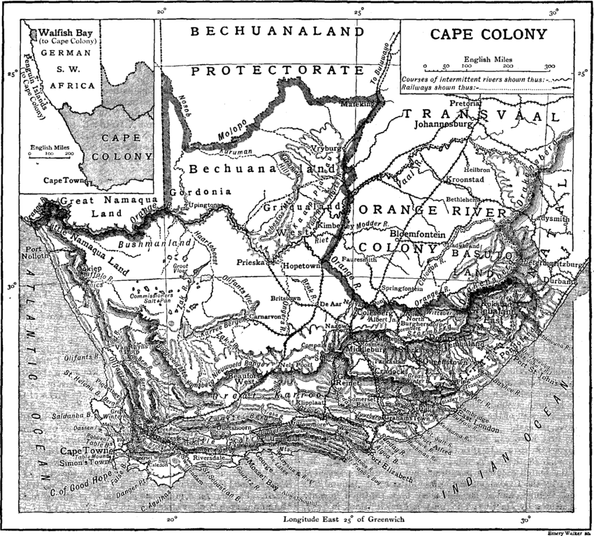
Mountains and Tablelands.—It has been stated that the land rises by well-marked steps to a vast central plateau. Beyond the coast plain, which here and there attains a height of 600 ft., are mountain ranges running parallel to the shore. These mountains are the supporting walls of successive terraces. When the steep southern sides of the ranges nearest the sea are ascended the hills are often found to be flat-topped with a gentle slope northward giving on to a plateau rarely more than 40 m. wide. This plateau is called the Southern or Little Karroo, Karroo being a corruption of a Hottentot word meaning dry, arid. Having crossed the Little Karroo, from which rise minor mountain chains, a second high range has to be climbed. This done the traveller finds himself on another tableland—the Great Karroo. It has an average width of 80 m. and is about 350 m. long. Northwards the Karroo (q.v.) is bounded by the ramparts of the great inner tableland, of which only a comparatively small portion is in Cape Colony. This sequence of hill and plain—namely (1) the coast plain, (2) first range of hills, (3) first plateau (Little Karroo), (4) second range of hills, (5) second plateau (the Great Karroo), (6) main chain of mountains guarding, (7) the vast interior tableland—is characteristic of the greater part of the colony but is not clearly marked in the south-east and north-west borders. The innermost, and most lofty, chain of mountains follows a curve almost identical with that of the coast at a general distance of 120 m. from the ocean. It is known in different places under different names, and the same name being also often given to one or more of the coast ranges the nomenclature of the mountains is confusing (see the map). The most elevated portion of the innermost range, the Drakensberg (q.v.) follows the curve of the coast from south to north-east. Only the southern slopes of the range are in Cape Colony, the highest peaks—over 10,000 ft.—being in Basutoland and Natal. Going westward from the Drakensberg

