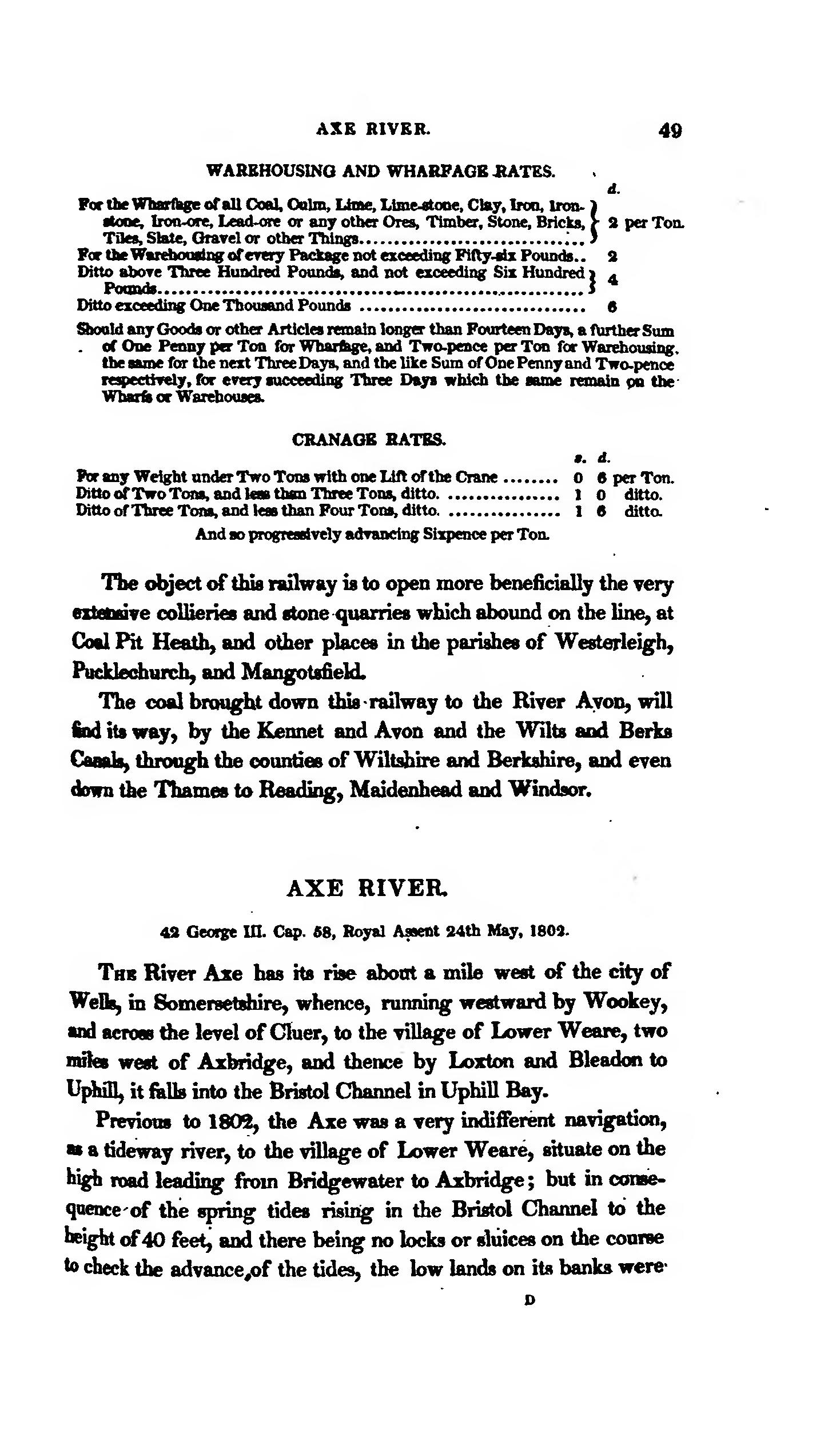
WAREHOUSING AND WHARFAGE RATES
| d. | |||
| For the Wharfage of all Coal, Culm, Lime, Lime-stone, Clay, Iron, Ironstone. Iron-ore, Lead-ore or any other Ores, Timber, Stone, Bricks, Tiles, Slate, Gravel or other Things | 2 | per Ton. | |
| For the Warehousing of every Package not exceeding Fifty-six Pounds. | 2 | ||
| Ditto above Three Hundred Pounds, and not exceeding Six Hundred Pounds | 4 | ||
| Ditto exceeding One Thousand Pounds | 6 |

CRANAGE RATES.
| s. | d. | ||
| Per any Weight under Two Tons with one Lift of the Crane | 0 | 6 | per Ton. |
| Ditto of Two Tons, and less than Three Tons, ditto | 1 | 0 | ditto. |
| Ditto of Three Tons, and less than Four Tons, ditto. | 1 | 6 | ditto. |
| And so progressively advancing Sixpence per Ton. |
The object of this railway is to open more beneficially the very extensive collieries and stone quarries which abound on the line, at Coal Pit Heath, and other places in the parishes of Westerleigh, Pucklechurch, and Mangotsfield.
The coal brought down this railway to the River Avon, will find its way, by the Kennet and Avon and the Wilts and Berks Canals, through the counties of Wiltshire and Berkshire, and even down the Thames to Reading, Maidenhead and Windsor.
AXE RIVER.
42 George III. Cap. 58, Royal Assent 24th May, 1802.
The River Axe has its rise about a mile west of the city of Wells, in Somersetshire, whence, running westward by Wookey, and across the level of Cluer, to the village of Lower Weare, two miles west of Axbridge, and thence by Loxton and Bleadon to Uphill, it falls into the Bristol Channel in Uphill Bay.
Previous to 1802, the Axe was a very indifferent navigation, as a tideway river, to the village of Lower Weare, situate on the high road leading from Bridgewater to Axbridge; but in consequence of the spring tides rising in the Bristol Channel to the height of 40 feet, and there being no locks or sluices on the course to check the advance of the tides, the low lands on its banks were
