Transactions of the Geological Society, 1st series, vol. 2/Plates and Maps
PLATES AND MAPS
IN ILLUSTRATION OF
THE SECOND VOLUME
OF THE
TRANSACTIONS
OF
THE GEOLOGICAL SOCIETY.
LONDON:
Printed and sold by William Phillips, George Yard, Lombard street.
───────
1814
DESCRIPTION OF THE PLATES.
PLATE I.
Map and Sections of the Isle of Man, in illustration of Dr. Berger's paper, Page 29.
| In the upper Section | a b | is the upper limit of arable Land at the height of 937 feet above the sea. |
| c d | is the lower limit of Turbary ground, at the height of 1378 feet above the sea. | |
| e f | is the lower limit of Turbary ground, in another part of the island, at the height of 692 feet above the sea. |
The Figures in the Map refer to the names of the Hills.—Vide Table, beginning at page 62.
PLATE 2.
Fig. 1. Plan of the Vitrified Fort of Dun Mac Sniochain, described by Dr. MacCulloch, p. 257.
Fig. 2, 3. Plan and Section of the Coal-field at Bradford, near Manchester, described by Mr. Bakewell, p. 282.
PLATES 3, 4, 5.
In illustration of Dr. Mac Culloch's paper on the Granite Tors of Cornwall, p. 66.
Plate 3. The Logging Rock at the Land's End, as it appeared in 1796, described, p. 67.
Plate 4. The Cheese-wring near Liskeard, described, p. 69.
Plate 5. The Vixen Tor, on Dartmoor, described, p. 70.
PLATES 6, 7, 8.
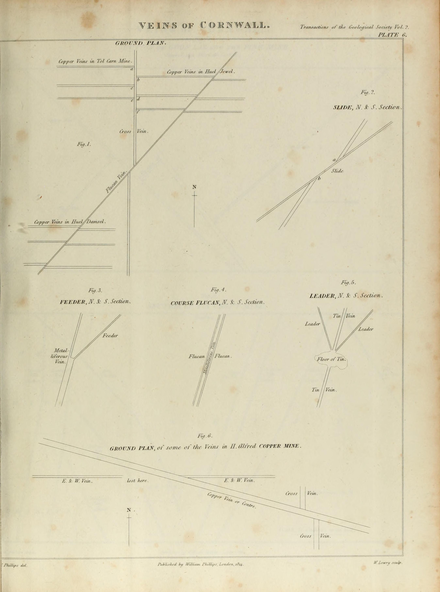
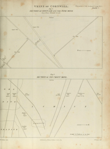
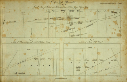
In illustration of Mr. William Phillips's paper on the Veins of Cornwall, p. 110.
Plate 6. Fig. 1. Ground Plan of Veins in Tol Carn, Huel jewel, and Huel Damsel Mines, p. 155.
2. Slide, p. 136.
3. Feeder, p. 138.
4. Course Flucan, p. 126.
5. Leader, p. 138.
6. Ground Plan of Veins in Huel Alfred, p. 157.
Plate 7. fig. 7. Section of the Goon Laz and the Pink Mine, p. 137.
8. Section of Tin Croft Mine, p. 152.
Plate 8. Fig. 9. Ground Plan of Herland and Drannack and Prince George Copper Mines, p. 146.
10. Section of Pleasure, Fancy, and North Herland Veins, p. 149.
11. Section of Manor Old Vein, p. 151.
PLATE 9, 10, 10*, 11.
In illustration of Mr. Webster's paper on the Strata lying over the Chalk, p. 161.
Plate 9. Map of the Basin of the Isle of Wight, shewing the hollow occasioned by a depression in the chalk within which some of the more recent strata appear to have been deposited; and also a part of the district in which the chalk is found wanting, where the strata below the chalk are exposed, p. 168 and 170. The detached figure below represents on a larger scale the west end of the Isle of Wight, where the Section of Pl. 11 is taken.
Plate 10. Map of a similar Basin in the vicinity of London, p. 171, 172.
Plate 10*. Map, shewing the relative position of the Basins of Paris, London, and the Isle of Wight.
Plate 11. Section of the Isle of Wight, from north to south, shewing the middle range of hills, consisting of strata of chalk, very highly inclined; the horizontal strata inferior to the chalk on the south, (right side of the plate); and the vertical strata of Alum Bay to the north, of later date than the chalk. Against the latter the horizontal and alternating series of marine and freshwater strata in Headen Hill, come up almost abruptly. The coloured section represents Alum Bay and Headen Hill on a larger scale.—p. 189.et. seq.
PLATES 12 and 13.
In illustration of Dr. Mac Culloch's paper on the Junction of Trap and Sandstone at Stirling Castle, p. 305.
Plate 12. Gives a general view of the Rock where the junction takes place.
Plate 13. Is a more detailed representation of that part of the junction where the strata of sandstone are dislocated and broken. It exhibits also the different colours of the trap and sandstone. The white line, near the fragment, is a vein of calcareous spar, p. 306.
In illustration of the Rev. W. Conybeare's paper, on a remarkable class of Organic Impressions occurring in Nodules of Flint, p. 328.
PLATE 15 to 26.
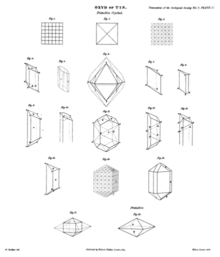
In illustration of Mr. William Phillips's paper on the Oxyd of Tin, p. 336.
Plate 15. Exhibits the practicable cleavages of the crystals of the oxyd of tin, leading to the determination that the primitive crystal is an obtuse octahedron, (Fig. 18.) p. 351. et seq.
Plate 16 to 23. Suite of crystalline forms, representing the existing crystals of this substance, with explanatory figures preceding the suite of each of the 12 modifications to which the primitive crystal is subject, p. 358. et seq.
Plate 24. Figures explanatory of the formation of simple and double macles, and shewing that they take place in the direction of the cleavages actually obtained and described by Pl. 15.—p. 366. et seq.
Plate 25. The crystalline forms of simple and double macles, p. 368. et seq.
Plate 26. The crystalline forms of macles of macles, shewing that they also take place in the direction of the cleavages, described by Pl. 15. p. 374.
PLATE 27 to 30.
In illustration of Mr. Webster's paper on Fossil Alcyonia, p. 377.
Plate 27, 28. Various appearances of the Tulip Alcyonium. The heads drawn in Pl. 28, are about half the size of the originals.
Plate 29. Fig. 12, 13. Various sections of the same fossil, p. 381.
Fig. 14, 15. Other species of Fossil Alcyonia. p. 386.
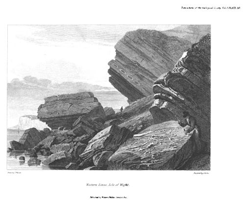
Plate 30. View of Western Lines on the south shore of the Isle of Wight, where the tulip alcyonium is best observed.
PLATE 31, 31†, and 32. Fig. 1
In illustration of Dr. Mac Culloch's paper, on the Geology of various Parts of Scotland, p. 388.
Plate 31. Fig. 1 & 2. Contortions in mica slate, at Loch Lomond, p. 438.
Plate 31†. Fig. 3. Another example of contortion in mica slate in Ardgowar, p. 438.
The other figures exhibit various instances of curvature and contortion in veins of granite and quartz, traversing gneiss and mica slate, in different parts of Scotland, p. 439 and 440.
Plate 32. Fig. 1. Contortion of mica slate at Loch Lomond, p. 438.
PLATE 32, Fig. 2.
View of the coast off the Row-storr of Assynt, intended to shew the detached position of the quartz rock mountains. The conical mountain on the left is the Sugar-Loaf at the entrance of Loch Inver and Loch Enard; on the right is the entrance of Loch Broom and Loch Groinard, p. 458.
In illustration of the Rev. J. J. Conybeare's paper on Clovelly, North Devon, p. 495.
In illustration of Dr. MacCulloch's paper on Staffa, p. 501, and described; p. 507.
PLATE 36, 37, 38, 39.
In illustration of Dr. MacCulloch's paper on Vegetable Remains preserved in Chalcedony, p. 510.
Plate 36, described p. 523.
─── 37, ──────── 524.
─── 38, ──────── 526.
─── 39, ──────── 526.
N. B. The Figure attached to each Specimen is intended to express the number of times it is magnified in the Drawing.


