File:Deception-Island-Map.jpg

Size of this preview: 378 × 600 pixels. Other resolutions: 151 × 240 pixels | 302 × 480 pixels | 484 × 768 pixels | 645 × 1,024 pixels | 1,302 × 2,065 pixels.
Original file (1,302 × 2,065 pixels, file size: 499 KB, MIME type: image/jpeg)
| This is a file from the Wikimedia Commons. Information from its description page there is shown below. Commons is a freely licensed media file repository. You can help. |
Summary
| Description |
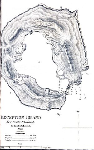
English: Map created on the first scientific expedition to Deception Island in 1829 under the command of captain Henry Foster. Originally published in Journal of the Royal Geographic Society Vol. 1 facing page 65. |
| Date | |
| Source | http://mappery.com/fullsize-name/Deception-Island-Map |
| Author | Lieut. E.N. Kendall |
Licensing
|
The author died in 1845, so this work is in the public domain in its country of origin and other countries and areas where the copyright term is the author's life plus 100 years or fewer. This work is in the public domain in the United States because it was published (or registered with the U.S. Copyright Office) before January 1, 1929. | |
| This file has been identified as being free of known restrictions under copyright law, including all related and neighboring rights. | |
File history
Click on a date/time to view the file as it appeared at that time.
| Date/Time | Thumbnail | Dimensions | User | Comment | |
|---|---|---|---|---|---|
| current | 11:31, 11 November 2009 | | 1,302 × 2,065 (499 KB) | 4ing | {{Information |Description={{en|1=Map created on the first scientific expedition to Deception Island in 1829 under the command of captain Henry Foster.}} |Source=http://mappery.com/fullsize-name/Deception-Island-Map |Author=Lieut. E.N. Kendall |Date=1829 |
File usage
The following 2 pages use this file:
Global file usage
The following other wikis use this file:
- Usage on cs.wikipedia.org
- Usage on de.wikipedia.org
- Usage on en.wikipedia.org
- Usage on eo.wikipedia.org
- Usage on es.wikipedia.org
- Usage on gl.wikipedia.org
- Usage on he.wikipedia.org
- Usage on mk.wikipedia.org
- Usage on pl.wikipedia.org
- Usage on zh.wikipedia.org