File:Mali-CIA WFB Map.png
No higher resolution available.
Mali-CIA_WFB_Map.png (330 × 353 pixels, file size: 19 KB, MIME type: image/png)
| This is a file from the Wikimedia Commons. Information from its description page there is shown below. Commons is a freely licensed media file repository. You can help. |
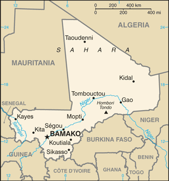
Summary
updated map of Mali from the CIA World Factbook - 24 July 2008 edition: https://www.cia.gov/library/publications/the-world-factbook/maps/ml-map.gif
- See also the 2004 version.
.png)
This image is in the public domain because it contains materials that originally came from the United States Central Intelligence Agency's World Factbook.
|
 |
File history
Click on a date/time to view the file as it appeared at that time.
| Date/Time | Thumbnail | Dimensions | User | Comment | |
|---|---|---|---|---|---|
| current | 02:15, 26 July 2008 | | 330 × 353 (19 KB) | Hoshie | updated map of Mali from the CIA World Factbook - 24 July 2008 edition: https://www.cia.gov/library/publications/the-world-factbook/maps/ml-map.gif |
| 09:16, 27 March 2005 |  | 350 × 376 (11 KB) | Wolfman~commonswiki | {{CIA-map}} |
File usage
The following page uses this file:
Global file usage
The following other wikis use this file:
- Usage on arz.wikipedia.org
- Usage on ca.wikipedia.org
- Usage on el.wikipedia.org
- Usage on en.wikipedia.org
- Usage on ff.wikipedia.org
- Usage on ilo.wikipedia.org
- Usage on ja.wikipedia.org
- Usage on kn.wikipedia.org
- Usage on lt.wiktionary.org
- Usage on ml.wikipedia.org
- Usage on pl.wikipedia.org
- Usage on simple.wikipedia.org
- Usage on si.wikipedia.org
- Usage on sl.wikipedia.org
- Usage on th.wikipedia.org
- Usage on uz.wikipedia.org