File:Mongolia CIA map.png
No higher resolution available.
Mongolia_CIA_map.png (630 × 318 pixels, file size: 12 KB, MIME type: image/png)
| This is a file from the Wikimedia Commons. Information from its description page there is shown below. Commons is a freely licensed media file repository. You can help. |
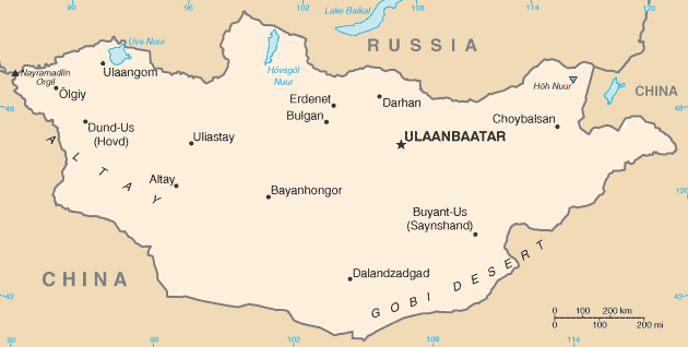
| Description | Map of Mongolia (English text) showing major towns. | |||
| Date | ||||
| Source | CIA, The World Factbook, 2004 | |||
| Author | CIA | |||
| Permission (Reusing this file) |
|

derivative works
Derivative works of this file: Mg-loc-gebril-map.png
File history
Click on a date/time to view the file as it appeared at that time.
| Date/Time | Thumbnail | Dimensions | User | Comment | |
|---|---|---|---|---|---|
| current | 12:47, 13 March 2022 | | 630 × 318 (12 KB) | Lojwe | Cropped 1 % horizontally, 2 % vertically using CropTool with precise mode. |
| 20:48, 4 March 2005 |  | 634 × 323 (13 KB) | Alfio | CIA map of Mongolia |
File usage
The following page uses this file:
Global file usage
The following other wikis use this file:
- Usage on af.wikipedia.org
- Usage on ar.wikipedia.org
- Usage on ast.wikipedia.org
- Usage on be-tarask.wikipedia.org
- Usage on bs.wikipedia.org
- Usage on ca.wikipedia.org
- Usage on ckb.wikipedia.org
- Usage on de.wikivoyage.org
- Usage on dsb.wikipedia.org
- Usage on en.wikipedia.org
- Usage on es.wikipedia.org
- Usage on fa.wikipedia.org
- Usage on fi.wikipedia.org
- Usage on fr.wikipedia.org
- Usage on fy.wikipedia.org
- Usage on he.wikipedia.org
- Usage on hu.wikipedia.org
- Usage on id.wikipedia.org
- Usage on ilo.wikipedia.org
- Usage on it.wikipedia.org
- Usage on ja.wikipedia.org
- Usage on ka.wikipedia.org
- Usage on kbp.wikipedia.org
- Usage on ko.wikipedia.org
- Usage on lt.wikipedia.org
- Usage on lt.wiktionary.org
- Usage on mg.wikipedia.org
- Usage on mn.wikipedia.org
- Usage on mr.wikipedia.org
- Usage on ms.wikipedia.org
- Usage on mt.wikipedia.org
- Usage on mwl.wikipedia.org
- Usage on nl.wikipedia.org
- Usage on nn.wikipedia.org
- Usage on os.wikipedia.org
- Usage on pam.wikipedia.org
- Usage on pl.wikipedia.org
View more global usage of this file.