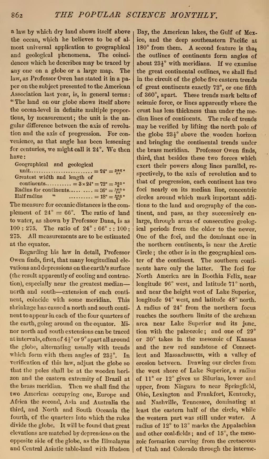
a law. by which dry land shows itself above the ocean, which he believes to be of almost universal application to geographical and geological phenomena. The coincidences which he describes may be traced by any one on a globe or a large map. The law, as Professor Owen has stated it in a paper on the subject presented to the American Association last year, is, in general terms: "The land on our globe shows itself above the ocean-level in definite multiple proportions, by measurement; the unit is the angular difference between the axis of revolution and the axis of progression. For convenience, as that angle has been lessening for centuries, we might call it 24°. We then have:
| Geographical and geological unit | 24° | 360°15 | |
| Greatest width and length of continents | 3 x 24° | 72° | 360°5 |
| Radius for continents | 36° | 360°10 | |
| Half radius " | 18° | 360°20 |

The measure for oceanic distances is the complement of 24° 66°. The ratio of land to water, as shown by Professor Dana, is as 100: 275. The ratio of 24°: 66°:: 100: 275. All measurements are to be estimated at the equator.
Regarding his law in detail, Professor Owen finds, first, that many longitudinal elevations and depressions on the earth's surface (the result apparently of cooling and contraction), especially near the greatest median—north and south—extension of each continent, coincide with some meridian. This shrinkage has caused a north and south continent to appear in each of the four quarters of the earth, going around on the equator. Minor north and south extensions can be traced at intervals, often of 412° or 9° apart all around the globe, alternating usually with trends which form with them angles of 2312°. In verification of this law, adjust the globe so that the poles shall be at the wooden horizon and the eastern extremity of Brazil at the brass meridian. Then we shall find the two Americas occupying one, Europe and Africa the second, Asia and Australia the third, and North and South Oceania the fourth, of the quarters into which the rules divide the globe. It will be found that great elevations are matched by depressions on the opposite side of the globe, as the Himalayas and Central Asiatic table-land with Hudson Bay, the American lakes, the Gulf of Mexico, and the deep southeastern Pacific at 180° from them. A second feature is that the outlines of continents form angles of about 2312° with meridians. If we examine the great continental outlines, we shall find in the circuit of the globe five eastern trends of great continents exactly 72°, or one fifth of 360°, apart. These trends mark belts of seismic force, or lines apparently where the crust has less thickness than under the median lines of continents. The rule of trends may be verified by lifting the north pole of the globe 2312° above the, wooden horizon and bringing the continental trends under the brass meridian. Professor Owen finds, third, that besides these two forces which exert their powers along lines parallel, respectively, to the axis of revolution and to that of progression, each continent has two foci nearly on its median line, concentric circles around which mark important additions to the land and orography of the continent, and pass, as they successively enlarge, through areas of consecutive geological periods from the older to the newer. One of the foci, and the dominant one in the northern continents, is near the Arctic Circle; the other is in the geographical center of the continent. The southern continents have only the latter. The foci for North America are in Boothia Felix, near longitude 96° west, and latitude 71° north, and near the height west of Lake Superior, longitude 94° west, and latitude 48° north. A radius of 24° from the northern focus reaches the southern limits of the archæan area near Lake Superior and its junction with the palæozoic; and one of 29° or 30° takes in the mesozoic of Kansas and the new red sandstone of Connecticut and Massachusetts, with a valley of erosion between. Drawing our circles from the west shore of Lake Superior, a radius of 11° or 12° gives us Silurian, lower and upper, from Niagara to near Springfield, Ohio, Lexington and Frankfort, Kentucky, and Nashville, Tennessee, dominating at least the eastern half of the circle, while the western part was still under water. A radius of 12° to 13° marks the Appalachian and other coal-fields; and of 15°, the mesozoic formation curving from the cretaceous of Utah and Colorado through the interme-