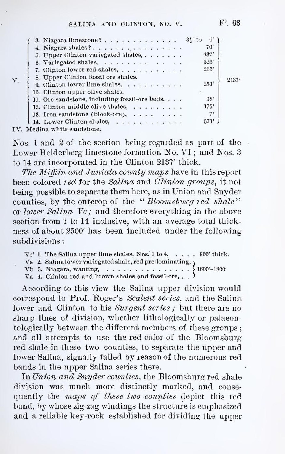
| V. | 3. | Niagara limestone? | 3½′ to 4′ | 2137′ | |||
| 4. | Niagara shales? | 70′ | |||||
| 5. | Upper Clinton variegated shales, | 432' | |||||
| 6. | Variegated shales, | 326′ | |||||
| 7. | Clinton lower red shales, | 260′ | |||||
| 8. | Upper Clinton fossil ore shales. | ||||||
| 9. | Clinton lower lime shales, | 251′ | |||||
| 10. | Clinton upper olive shales. | ||||||
| 11. | Ore sandstone, including fossil-ore beds, | 38′ | |||||
| 12. | Clinton middle olive shales, | 175′ | |||||
| 13. | Iron sandstone (block-ore), | 7′ | |||||
| 14 | Lower Clinton shales, | 571′ | |||||
| IV. | Medina white sandstone. | ||||||


Nos. 1 and 2 of the section being regarded as part of the Lower Helderberg limestone formation No. VI; and Nos. 3 to 14 are incorporated in the Clinton 2137′ thick.
The Miffiin and Juniata county maps have in this report been colored red for the Salina and Clinton groups, it not being possible to separate them here, as in Union and Snyder counties, by the outcrop of the “Bloomsburg red shale” or lower Salina Vc; and therefore everything in the above section from 1 to 14 inclusive, with an average total thickness of about 2500′ has been included under the following subdivisions:
| Vc′ | 1. The Salina upper lime shales, Nos. 1 to 4, | 900′ thick. | |
| Vc | 2. Salina lower variegated shale, red predominating, | 1600′–1800′ | |
| Vb | 3. Niagara, wanting, | ||
| Va | 4. Clinton red and brown shales and fossil-ore, |

According to this view the Salina upper division would correspond to Prof. Roger’s Scalent series, and the Salina lower and Clinton to his Surgent series; but there are no sharp lines of division, whether lithologically or palaeontologically between the different members of these groups; and all attempts to use the red color of the Bloomsburg red shale in these two counties, to separate the upper and lower Salina, signally failed by reason of the numerous red bands in the upper Salina series there.
In Union and Snyder counties, the Bloomsburg red shale division was much more distinctly marked, and consequently the maps of these two counties depict this red band, by whose zig-zag windings the structure is emphasized and a reliable key-rock established for dividing the upper