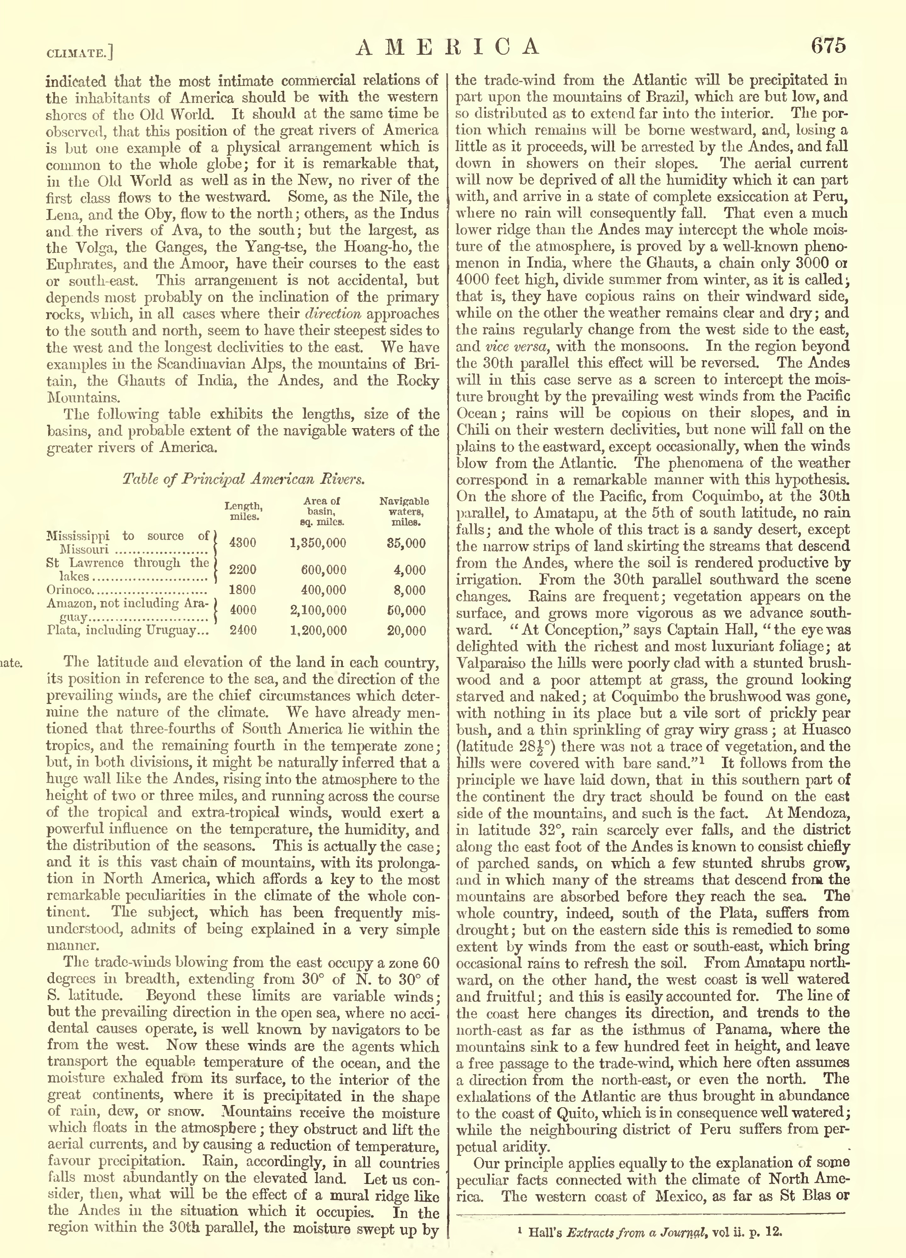
CLIMATE.] AMERICA 675 indicated that the most intimate commercial relations of the inhabitants of America should be with the western shores of the Old World. It should at the same time be observed, that this position of the great rivers of America is but one example of a physical arrangement which is common to the whole globe; for it is remarkable that, in the Old World as well as in the New, no river of the first class flows to the westward. Some, as the Nile, the Lena, and the Oby, flow to the north; others, as the Indus and. the rivers of Ava, to the south; but the largest, as the Volga, the Ganges, the Yang-tse, the Hoang-ho, the Euphrates, and the Amoor, have their courses to the east or south-east. This arrangement is not accidental, but depends most probably on the inclination of the primary rocks, which, in all cases where their direction approaches to the south and north, seem to have their steepest sides to the west and the longest declivities to the east. We have examples in the Scandinavian Alps, the mountains of Bri tain, the Ghauts of India, the Andes, and the Kocky Mountains. The following table exhibits the lengths, size of the basins, and probable extent of the navigable waters of the greater rivers of America. Table of Principal American Rivers. Mississippi to source of Missouri St Lawrence through, the lakes Orinoco Amazon, not including Ara- Plata, including Uruguay... Length, miles. 4300 2200 1800 4000 2400 Area of basin, sq. miles. 1,350,000 600,000 400,000 2,100,000 1,200,000 Navigable waters, miles. 35,000 4,000 8,000 50,000 20,000 The latitude and elevation of the land in each country, its position in reference to the sea, and the direction of the prevailing winds, are the chief circumstances which deter mine the nature of the climate. We have already men tioned that three-fourths of South America lie within the tropics, and the remaining fourth in the temperate zone; but, in both divisions, it might be naturally inferred that a huge wall like the Andes, rising into the atmosphere to the height of two or three miles, and running across the course of the tropical and extra-tropical winds, would exert a powerful influence on the temperature, the humidity, and the distribution of the seasons. This is actually the case ; and it is this vast chain of mountains, with its prolonga tion in North America, which affords a key to the most remarkable peculiarities in the climate of the whole con tinent. The subject, which has been frequently mis understood, admits of being explained in a very simple manner. The trade-winds blowing from the east occupy a zone 60 degrees in breadth, extending from 30 of N. to 30 of S. latitude. Beyond these limits are variable winds; but the prevailing direction in the open sea, where no acci dental causes operate, is well known by navigators to be from the west. Now these winds are the agents which transport the equable temperature of the ocean, and the moisture exhaled from its surface, to the interior of the great continents, where it is precipitated in the shape of rain, dew, or snow. Mountains receive the moisture which floats in the atmosphere ; they obstruct and lift the aerial currents, and by causing a reduction of temperature, favour precipitation. Rain, accordingly, in all countries falls most abundantly on the elevated land. Let us con sider, then, what will be the effect of a mural ridge like the Andes in the situation which it occupies. In the region within the 30th parallel, the moisture swept up by the trade-wind from the Atlantic will be precipitated in part upon the mountains of Brazil, which are but low, and so distributed as to extend far into the interior. The por tion which remains will be borne westward, and, losing a little as it proceeds, will be arrested by the Andes, and fall down in showers on their slopes. The aerial current will now be deprived of all the humidity which it can part with, and arrive in a state of complete exsiccation at Peru, where no rain will consequently fall. That even a much lower ridge than the Andes may intercept the whole mois ture of the atmosphere, is proved by a well-known pheno menon in India, where the Ghauts, a chain only 3000 01 4000 feet high, divide summer from winter, as it is called , that is, they have copious rains on their windward side, while on the other the weather remains clear and dry ; and the rains regularly change from the west side to the east, and vice versa, with the monsoons. In the region beyond the 30th parallel this effect will be reversed. The Andes will in this case serve as a screen to intercept the mois ture brought by the prevailing west winds from the Pacific Ocean ; rains will be copious on their slopes, and in Chili on their western declivities, but none will fall on the plains to the eastward, except occasionally, when the winds blow from the Atlantic. The phenomena of the weather correspond in a remarkable manner with this hypothesis. On the shore of the Pacific, from Coquimbo, at the 30th parallel, to Amatapu, at the 5th of south latitude, no rain falls; and the whole of this tract is a sandy desert, except the narrow strips of land skirting the streams that descend from the Andes, where the soil is rendered productive by irrigation. From the 30th parallel southward the scene changes. Rains are frequent; vegetation appears on the surface, and grows more vigorous as we advance south ward. "At Conception," says Captain Hall, "the eye was delighted with the richest and most luxuriant foliage; at Valparaiso the hills were poorly clad with a stunted brush wood and a poor attempt at grass, the ground looking starved and naked ; at Coquimbo the brushwood was gone, with nothing in its place but a vile sort of prickly pear bush, and a thin sprinkling of gray wiry grass ; at Huasco (latitude 2S|) there was not a trace of vegetation, and the hills were covered with bare sand." 1 It follows from the principle we have laid down, that in this southern part of the continent the dry tract should be found on the east side of the mountains, and such is the fact. At Mendoza, in latitude 32, rain scarcely ever falls, and the district along the east foot of the Andes is known to consist chiefly of parched sands, on which a few stunted shrubs grow, and in which many of the streams that descend from the mountains are absorbed before they reach the sea. The whole country, indeed, south of the Plata, suffers from drought ; but on the eastern side this is remedied to some extent by winds from the east or south-east, which bring occasional rains to refresh the soil. From Amatapu north ward, on the other hand, the west coast is well watered and fruitful ; and this is easily accounted for. The line of the coast here changes its direction, and trends to the north-east as far as the isthmus of Panama, where the mountains sink to a few hundred feet in height, and leave a free passage to the trade-wind, which here often assumes a direction from the north-east, or even the north. The exhalations of the Atlantic are thus brought in abundance to the coast of Quito, which is in consequence well watered; while the neighbouring district of Peru suffers from per petual aridity. Our principle applies equally to the explanation of some peculiar facts connected with the climate of North Ame rica. The western coast of Mexico, as far as St Bias or
1 Hall s Extracts from a Joum&l, vol ii. p. 12.
